A new online tool has been developed that makes it possible for anyone to identify hidden vessels operating in Danish waters, enhancing maritime security.
Using satellite data, artificial intelligence and open maritime databases, a researcher from DTU Space – the short name for the Space Department/Institute at the Technical University of Denmark (DTU) – has developed an online tool that makes it possible to track the movements of ships in Danish waters, including vessels attempting to hide, according to a DTU Space press release.
This also includes ships attempting to hide by switching off their so-called AIS transponders, which reveal their position.
Behind the project is Peder Heiselberg, a postdoc at DTU Space, who has developed the freely accessible platform OpenOceanWatch.
This is stated by the DTU Space – Department of Space Research and Space Technology in a release.
“We don’t always have the opportunity to keep track of what’s happening at sea. That’s why I wanted to create a tool where anyone can freely access and view activity in Danish waters,” says Peder Heiselberg.
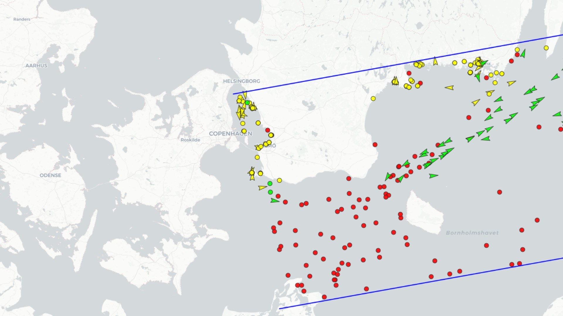
All vessels detected by the system in the area are marked on a map. This includes ships that do not transmit the active AIS signal, which is normally used to display a ship’s identity, course and speed, in order to avoid collisions, amongst other things. When the system detects an unknown vessel without an identifiable signal, it is marked in red, the statement of the DTU reads.
A quick glance at the map shows that there are several vessels in Danish waters that have no or have turned off their AIS transponders, which are mandatory for larger merchant ships, passenger ships and larger fishing vessels.
“These could, for example, be vessels involved in illegal fishing. However, not all vessels are legally required to have a transponder on board,” says Peder Heiselberg, pointing out that there is no requirement for AIS transponders for recreational sailors, for example.
As explained in the DTU’s release, the system automatically cross-references the satellite observations with open databases of ships’ AIS signals. If there is a match, it is marked in green as verified traffic. If there is no match, it is marked in red. In cases where an AIS signal is present, but satellite photos do not show a ship, it is marked in yellow.
Although the tool has been trained on a vast array of different ships and satellite images, Heiselberg emphasizes that it can make errors, just as there may be errors in the open databases it utilises. A red marking cannot therefore be said with certainty to be a ‘ghost ship’, according to the DTU Space release.
The Automatic Identification System, abbreviated to AIS, is a radio system that transmits information about a vessel’s name, position, course and speed. The system is based on transponders that automatically and continuously receive and transmit AIS signals.
According to Peder Heiselberg, the tool can be used, among other things, to investigate incidents involving critical infrastructure such as internet cables, pipelines and offshore wind turbines.
“It is only in recent years, particularly following the sabotage of Nord Stream 2, that we have truly realised that the threat to, for example, critical Danish infrastructure is real. In these circumstances, I think it is exciting that everyone now has the opportunity to keep track of what is happening in our waters,” explains Peder Heiselberg.
The project stems from Peder Heiselberg’s PhD work and has been further developed with support from DTU Skylab through a Discovery Grant, which enables researchers to test and refine new ideas.
Source: DTU Space – Department of Space Research and Space Technology. Note: This article is for informational purposes only. The information provided in this article does not constitute or replace professional advice. Any reliance you may place on the information provided in this article is strictly at your own risk. Pls see our disclaimer here.